05/14 - Mt. Takekawadake (武川岳)
Hike through the new green leaves in May
Height: 1052 meters
Difficulty: Intermediate (中級者)
Hiking Time: 5 hours
Distance: 7.5 km
Maximum Elevation Change (最大標高差): 750 meters
Access: Ikebukuro Station-->Take the Seibu Ikebukuro Line to Shoumaru Station (正丸駅) (680 yen)-->Take a short taxi ride to Takekawadake. (*There is not a regular taxi service. The taxi company that picked us up charged 5800 yen to take us to the starting point at Naguri Genki Plaza)
Getting Back: Finish hike at Ashigakubo train station (芦ヶ久保駅)-->Take the Seibu Chichibu Railroad back to Ikebukuro .
The hike is actually three different mountains. Start by hiking up Mt. Takekawadake. From there, we'll head north to Mt. Yaki and Mt. Futago before reaching Ashigakubo station.
The hike is just to the east of Chichibu's Mt. Buko, which can be seen as you hike up Mt. Yaki. The second half of the hike gets quite rugged and is recommended for intermediate level. However, there isn't any particular dangerous spots. So, beginners can do the course too, as long as you have confidence in your legs. One thing to keep in mind is that there is no way to escape down if you are in the middle of the course. Your only option is to keep hiking to the end. Keep this in mind if you are hiking alone, as you'll pass through some areas inhabited by bears.
"関東のハイカーたちに人気の高い武川岳は、秩父の武甲山の東に位置する。ここで紹介するコースは後半がややきつく長いために、中級者向けのコースとしたが、特に危険な場所があるというわけではないので、ビギナーであっても、経験者と同行したり、また脚に自信があれば何ら問題はない" (Tokyo Yama Aruki Guide)
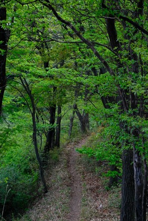
The hike up to the top of Takegawadake is somewhat steep, but quite pleasant in mid-May when the new green leaves are out and the nightengales are singing.
One type of flower which you may see in Spring is called "utsugi" (Japanese snow flower).
The summit of Takekawadake is a wide area, mostly surrounded by trees. It has a view of other mountains. However, the better views come from Mt. Yaki.
Difficulty: Intermediate (中級者)
Hiking Time: 5 hours
Distance: 7.5 km
Maximum Elevation Change (最大標高差): 750 meters
Access: Ikebukuro Station-->Take the Seibu Ikebukuro Line to Shoumaru Station (正丸駅) (680 yen)-->Take a short taxi ride to Takekawadake. (*There is not a regular taxi service. The taxi company that picked us up charged 5800 yen to take us to the starting point at Naguri Genki Plaza)
Getting Back: Finish hike at Ashigakubo train station (芦ヶ久保駅)-->Take the Seibu Chichibu Railroad back to Ikebukuro .
The hike is actually three different mountains. Start by hiking up Mt. Takekawadake. From there, we'll head north to Mt. Yaki and Mt. Futago before reaching Ashigakubo station.
The hike is just to the east of Chichibu's Mt. Buko, which can be seen as you hike up Mt. Yaki. The second half of the hike gets quite rugged and is recommended for intermediate level. However, there isn't any particular dangerous spots. So, beginners can do the course too, as long as you have confidence in your legs. One thing to keep in mind is that there is no way to escape down if you are in the middle of the course. Your only option is to keep hiking to the end. Keep this in mind if you are hiking alone, as you'll pass through some areas inhabited by bears.
"関東のハイカーたちに人気の高い武川岳は、秩父の武甲山の東に位置する。ここで紹介するコースは後半がややきつく長いために、中級者向けのコースとしたが、特に危険な場所があるというわけではないので、ビギナーであっても、経験者と同行したり、また脚に自信があれば何ら問題はない" (Tokyo Yama Aruki Guide)
The hike up to the top of Takegawadake is somewhat steep, but quite pleasant in mid-May when the new green leaves are out and the nightengales are singing.
One type of flower which you may see in Spring is called "utsugi" (Japanese snow flower).
The summit of Takekawadake is a wide area, mostly surrounded by trees. It has a view of other mountains. However, the better views come from Mt. Yaki.
Hiking to Mt. Yaki and Mt. Futago
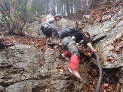
This was the most rugged photo I found.
The second half is 3.5 hour rugged hike north on a ridge to Ashigakubo Station. (芦ヶ久保駅). Along the way, we'll hike up Mt. Yaki, for a great view of Mt. Buko. We'll then continue to Mt. Futago.
The path will be a lot of tough ups and downs. It takes a total of 3.5 hours to reach the station. Most of the trail is rocky and rugged. There are several steep climbs down where you'll need to be careful not to slip and fall on your butt. We'll also pass through areas where bears are known to inhabit.
Onsen: There is no onsen by Ashigakubo Station.
There is an onsen at the NEXT station (横瀬駅) with an with an outdoor bath (露天風呂).
(秩父湯元武甲温泉)
It costs 800 yen and is open to 10PM.
Map
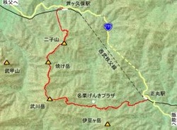
There are 3 main mountains we will be hiking. We will start by climbing Mt. Takekawadake. The second mountain is Mt. Yaki. The final mountain is Mt. Futago.
Yamabushi
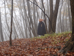
Yamabushi (or shugenjya) are ascetic hermits who follow "shugendo," an ancient Japanese religion that centers on man's relationship with nature and mountain-dwelling practices. Shugendo goes back to the 7th century, and includes parts of Buddhism, Shintoism and other influences. Those who follow shugendo embark on pilgramages and treks to earn experience and rank. The exact rituals are kept secret from the world at large. However, you may encounter a wandering priest, "hiding" in the mountains.
