Nikko's Takayama Mountain/高山
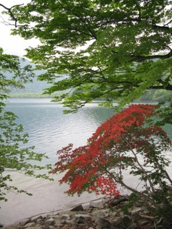
Lake Chuzenji near Mt. Takayama
Place: Takayama Mountain/高山
Height: 1668 meters
Hiking Time: 4 hours 20 minutes
Hiking Distance: 11.5km
Max. Elevation Difference (最大標高差): 370
Access:Take the Tobu Railroad to Nikko Station (東武鉄道ー>日光駅).
Change to Tobu Bus. Get off at Ryuuzunotaki (東武バスで竜頭ノ滝へ。
The mountain is great for viewing mizunara, karamatsu, harigiri, shirakaba, kaede trees. In early summer, there are various kinds of tsutsuji(azalea) and azumashakunage (アズマシャクナゲ) are beautiful. Near the lake Chuuuzenji, on Senjugahama, there will be clusters of Japanese primrose (Kurinsou クリンソウ) that are in bloom right around the start of summer after Japan's rainy season.
We will start by taking the bus from Nikko Station to Ryuuzunotaki (龍頭の滝). Here there is a tea house, and a waterfall. We'll also have a scenic view of the river and Lake Chuuzenji.
After getting energized, by the scenery here, we'll hike up to the top of Mt. Takayama. The forest is quite beautiful with lots of pines and broad-leaf trees. The summit of Mt. Takayama is surrounded by trees. So no view, but it is sunny and spacious enough to have lunch.
Looking down on Mt. Dantai and Lake Chuuzenji

Mt. Dantai and Lake Chuuzenji
Along the way up, we'll have a good view of Mt. Dantai as well as Lake Chuuzenji below.
We'll then hike down to Lake Chuuzenji. We'll pass through a "tunnel" of azalea flowers. On the way down there will be some steep slopes and a chain (kusruriba) to hold as you hike down.
However, it is not very dangerous (たいした危険はない).
After about an hour, we will reach a place called "Kuma Kubo." (Bear Hollow?). We'll then walk along the lake while looking at Mt. Dantai. Here, we'll walk over to a place called 千手ケ浜. There will be lots of clusters of Japanese primrose (Kurinsou クリンソウ).
Finally, we will backtrack about 1 hour along the beach and walk back to the waterfall and bus stop where we started.
Ryuuzu Waterfall
This is a 210 meter waterfall, that was formed when Mt. Dantai erupted. (It does not drop straight down, so you cannot see it all at once.) Look out for lots of photographers here in May and the fall.
